
The Island of
California refers to a long-held European misconception, dating from the 16th
century, that California was not part of mainland North America but rather a
large island separated from the continent by a strait now known as the Gulf of
California.
One of the most famous
cartographic errors in history, it was propagated on many maps during the 17th
and 18th centuries, despite contradictory evidence from various explorers. The
legend was initially infused with the idea that California was a terrestrial
paradise, like the Garden of Eden or Atlantis.
The first known mention
of the legend of the "Island of California" was in the 1510 romance
novel Las sergas de Esplandián by Garci Rodríguez de Montalvo—the sequel to
Montalvo's more famous tales of Amadis de Gaula, father of Esplandian. He
described the island in this passage:
Know, that on the right
hand of the Indies there is an island called California very close to the side
of the Terrestrial Paradise; and it is peopled by black women, without any man
among them, for they live in the manner of Amazons.
It is probable that
this description prompted early explorers to misidentify the Baja California
Peninsula as the island in these legends.
In 1533, Fortún
Ximénez, a mutineer on an exploring expedition sent by Hernán Cortés,
discovered the southern portion of Baja California, around present-day La Paz.
He was killed by natives but his men returned to New Spain and gave report of
their find. In 1535 Cortés arrived in the bay there and named the area Santa
Cruz; he attempted to start a colony but abandoned his efforts after several
years due to logistical problems. Cortés' limited information on southern Baja
California apparently led to the naming of the region after the legendary
California and to an initial but short-lived assumption that it was a large
island.
In 1539, Cortés sent
the navigator Francisco de Ulloa northward along the Gulf and Pacific coasts of
Baja California. Ulloa reached the mouth of the Colorado River at the head of
the Gulf, which seemed to prove that the region was a peninsula rather than an
island. An expedition under Hernando de
Alarcón ascended the lower Colorado River and confirmed Ulloa's finding. Maps
published subsequently in Europe during the 16th century, including those by
Gerardus Mercator and Abraham Ortelius, correctly showed Baja California as a
peninsula.
Despite this evidence,
however, the depiction of California as an island revived in the early 17th
century. One contributing factor may have been the second voyage of Juan de
Fuca in 1592. Fuca claimed to have explored the western coast of North America
and to have found a large opening that possibly connected to the Atlantic Ocean
— the legendary Northwest Passage. Fuca's claim remains controversial because
there is only one surviving written account of it found, his account as related
to an Englishman, Michael Locke. Nonetheless, this account claims Fuca found a
large strait, with a large island at its mouth, at around 47° north latitude.
The Strait of Juan de Fuca is in fact at around 48° N, as is the southern tip
of the large island now called Vancouver Island, while the northern reach of
the Gulf of California terminates much farther south, at about 31° N. It is
possible that explorers and mapmakers in the 17th century could have confused
the two (if in fact they were aware of Fuca's voyage), and in any case further
exploration was inevitable. Indeed, the famed British explorer James Cook
narrowly missed the Strait of Juan de Fuca in March 1778, almost 200 years
later. Cook even named Cape Flattery (at the northwest tip of modern Washington
state) which is at the mouth of the strait, and instead stopped in Nootka Sound
just off the west coast of Vancouver Island at about 49° N. His account states
"we saw nothing like [the Strait of Juan de Fuca]; nor is there the least
probability that ever any such thing existed."[5] However, Cook describes
some bad weather in his account around this time, and did continue on to map
most of the outer Pacific coastline of North America from modern-day northern
California to the Bering Strait in Alaska on the same voyage.
A key role in changing
ideas about California seems to have been played by an overland expedition led
by the founding governor of Santa Fe de Nuevo México, Juan de Oñate. The
expedition descended the Colorado River in 1604 and 1605, and its participants
believed that they saw the Gulf of California continuing off to the northwest
(presumably behind in the Sierra Cucapá into the Laguna Macuata Basin).
Reports from Oñate's
expedition reached Antonio de la Ascención, a Carmelite friar who had
participated in Sebastián Vizcaíno's explorations of the west coast of
California in 1602 and 1603. Ascención was a tireless propagandist in favor of
Spanish settlement in California, and his later writings referred to the region
as an island. As older maps confirm, Spanish authorities and local residents
were well aware where the actual northern terminus of the Gulf of California
lay, but by extending the coastline north past Cape Mendocino and eventually
even into Puget Sound, Sir Francis Drake's claim of Nova Albion for England
(1579) could be invalidated by the priority of Cortes' claim (1533).
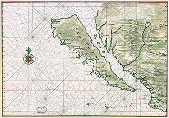
The first known
reappearance of the Island of California on a map dates to 1622 in a map by
Michiel Colijn of Amsterdam. The image became the standard for many later maps
throughout the 17th century and intermittently into the 18th century. Previous
maps show the Gulf terminating in its correct location. On the stretch of the
Gulf between its actual terminus and Juan de Fuca's strait was written Mare
Vermexo ("Red Sea") on later maps drawn from Spanish sources.
The Jesuit missionary
and cartographer Eusebio Francisco Kino revived the fact that Baja California
was a peninsula. While studying in Europe, Kino had accepted the insularity of
California, but when he reached Mexico he began to have doubts. He made a series
of overland expeditions from northern Sonora to areas within or near the
Colorado River's delta in 1698–1706, in part to provide a practical route
between the Jesuits' missions in Sonoran and Baja California but also to
resolve the geographical question. Kino satisfied himself that a land
connection must exist, and the 18th century Jesuits generally followed his
example. The first report of Kino's discovery and his map from 1701 showing
California as a peninsula were sent to Europe by Marcus Antonius Kappus, a
Jesuit missionary from Kamna Gorica (Duchy of Carniola, now Slovenia). In a
June 1701 letter, he wrote about that to his friend Philippus Alberth in Vienna
and thus acted as an important intermediary in the dissemination of this
knowledge. However, Juan Mateo Manje, a military companion on several of Kino's
treks, expressed scepticism; European cartographers remained divided on the
question.
Jesuit
missionary-explorers in Baja California who attempted to lay the issue finally
to rest included Juan de Ugarte (1721), Ferdinand Konščak (1746), and
Wenceslaus Linck (1766). The matter was settled beyond all dispute when the
expeditions of Juan Bautista de Anza traveled between Sonora and the west coast
of California in the period 1774–1776.
No comments:
Post a Comment